2023 Music Review
A look back at favourite albums and listening habits from the past twelve months.
⭐ Favourite 10 Albums

My favourite albums of the year were:
- Tracey Denim by bar italia
- Blondshell by Blondshell
- 3D Country by Geese
- In the Light of the Blistering Moon by How Strange It Is
- Time Ain't Accidental by Jess Williamson
- Versions Of Us by Lanterns on the Lake
- The Window by Ratboys
- Yard by Slow Pulp
- Dead Meat by The Tubs
- Heaven Is a Junkyard by Youth Lagoon
🎧 Listen to my playlist of favourite tracks from the year on Spotify
🎸 Last.fm Top Charts

I scrobbled a total of 13,777 tracks in 2023. My top 10 albums by Last.fm play count released in 2023 were:
- Heaven Is a Junkyard by Youth Lagoon (290 plays)
- Tracey Denim by bar italia (244 plays)
- First Two Pages of Frankenstein by The National (190 plays)
- No Joy by Spanish Love Songs (156 plays)
- The Dreamless Sleep Of The 1990s by Broken Records (149 plays)
- This Place We Live by Matthew And The Atlas (145 plays)
- the record by boygenius (141 plays)
- Desire, I Want To Turn Into You by Caroline Polachek (120 plays)
- In the Light of the Blistering Moon by How Strange It Is (111 plays)
- The Window by Ratboys (109 plays)
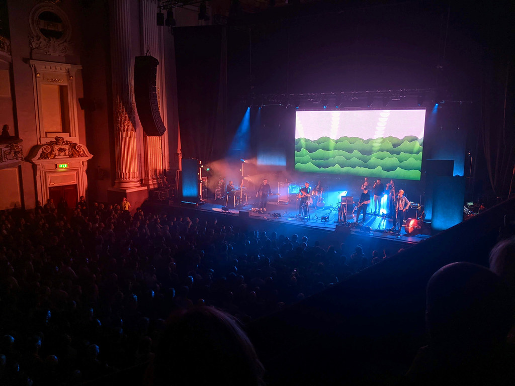
🎟️ Concerts
I managed two gigs in 2023, both in Glasgow, and both excellent.

On a sweltering May evening New Zealand power pop band The Beths played to a sold out Garage at the far end of Sauchiehall Street. My train ran late so I only caught the last couple of songs of support act Lande Hekt. The Beths arrived to rapturous applause and launched into an energetic set covering favourite songs from across their albums. Expert in a Dying Field, Future Me Hates Me and Silence Is Golden were all great and the bands introduction in the round brought out their quirky characters. It was over all too soon but hopefully they will be back.
Review and great concert photos from Dale Harvey on Re-sound and a video of Expert in a Dying Field on Youtube.

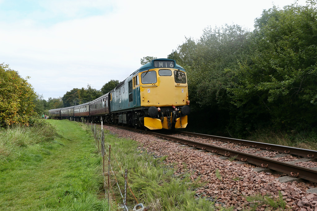
In complete contrast, a cold November night saw me at St Luke's in the east end of the city for Lanterns on the Lake. Supported by solo act Sophie Jamieson. Lanterns came on with two drummers; their usual drummer Matt Hardy was joined by Radiohead's Philip Selway who had helped rescue their 2023 album Versions of Us.
The new album featured heavily in the setlist with the new songs sounding great. The band have always had a talent for beautifully marrying the post-rock contrasts of quiet piano verses and bombastic guitar driven choruses. It was a stunning performance and the sound quality at St Luke's was excellent - clear and loud without being excessive.
📈 Spotify Wrapped


Winter Diesel Gala

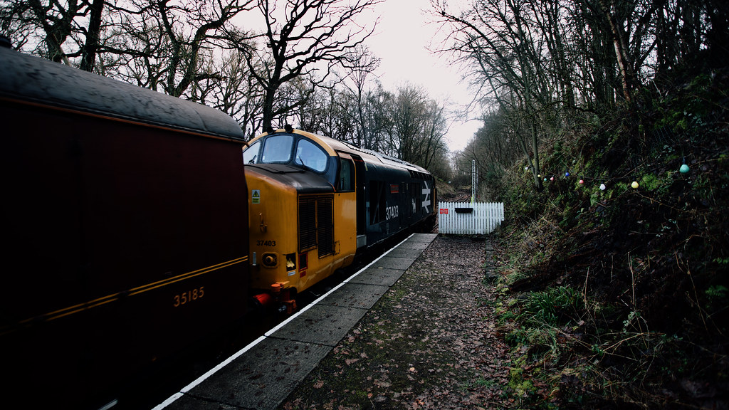
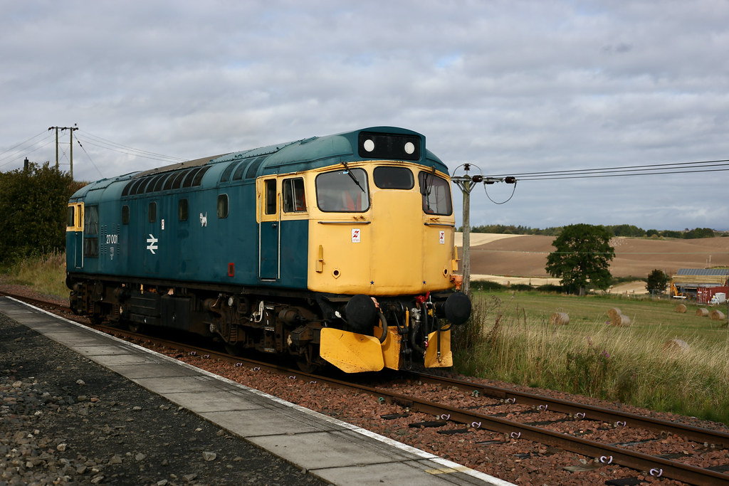
After a few days of cozy Christmas home comforts it was good to get out of the house and head along to the Bo'ness and Kinneil Railway for their Winter Diesel Gala.
The home locomotives 27001 and 37403 were joined by two guest class 70 locomotives provided by Colas Rail: 70807 and 70813. Throughout the day different combinations of these locos topped and tailed trains running up and down between Bo'ness and Manuel junction.

I decided to buy a Day Rover so that I could hop on and off trains and stay as long as I wished. This proved to be good value for money and I managed four round trips over the course of the day.

The early runs were delayed by some teething troubles with brakes on the coaching stock and the Class 70s were held back by an issue with the points off the mainline. On the second run up to Manuel the Class 70s were successfully attached to the front and back of the train. The late running meant that there often wasn't an opportunity to get off at Manuel so most of my photos were taken down at Bo'ness during shunting operations.

The first service of the day was fairly quiet but the second train was full of people and it continued that way for most of the day. I skipped one train around lunchtime whilst I stopped to get some food, but caught 37403 leading the train back along the foreshore which gave me some of the best photographic opportunities of the day.
With the sun setting by mid-afternoon I took one last run up to Manuel. This time the train stopped briefly at Birkhill station and I got off to have a look around; I've often thought about cycling up to Birkhill to watch the trains. After a wander around the station it was good to return to the warm train for the run back to Bo'ness as the sun set.
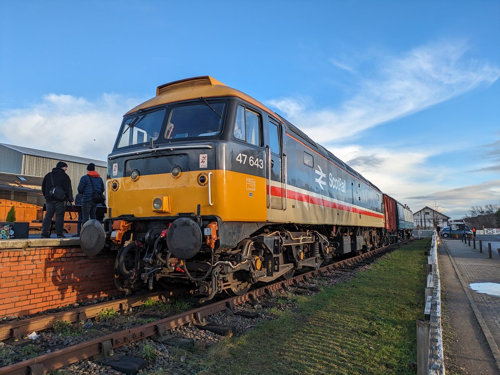
As well as the running locomotives, 47643 was stabled in the station's bay platform. This engine is needing wheel repairs and there is an ongoing crowdfunding campaign to raise the necessary funds.
There is a video from the day on Youtube here. You can see my full Flickr photo album here.
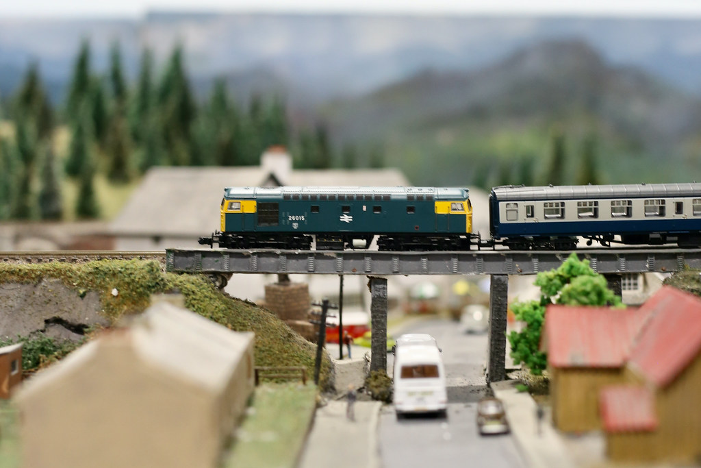
Heritage Diesel Day at Bo'ness and Kinneil Railway
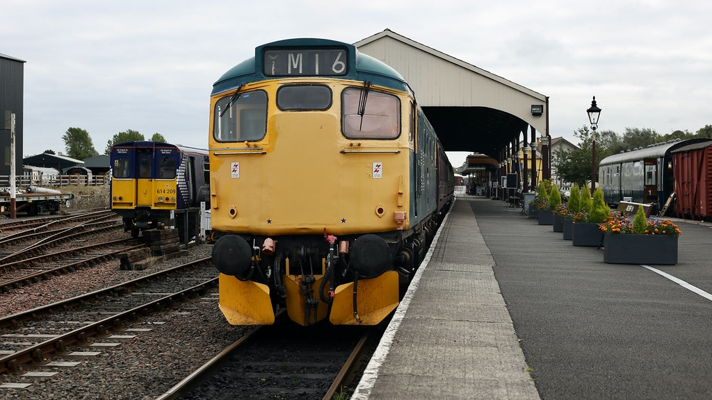
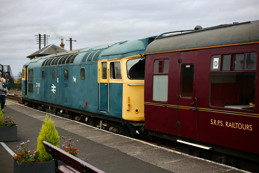
Today was a Heritage Diesel Day at the Bo'ness and Kinneil Railway, with 27 001, restored to service by the SRPS Diesel Group, running a number of trips between Bo'ness and Manuel Junction. Hoping for some mid-morning sunshine I headed to Bo'ness early on to find 27 001 already idling in the station with a rake of carriages.
I bought a ticket for the 10:30am departure from Bo'ness and then spent some time on the platform. As departure time neared I got a spot in the first carriage behind the locomotive and settled in to enjoy the short ride up to Manuel. Despite having been to Bo'ness on a few occasions, this would be my first trip on the railway.

The line runs through trees outside Bo'ness before turning north and traversing more open countryside as it climbs towards the mainline at Manuel junction. The leaves are just starting to turn and the occasional sunshine brought some much needed light to the landscape. After the pretty station of Birkhill the Avon viaduct provides a final grand vista before the end of the line is reached.

At Manuel the locomotive was disconnected and run around the carriages for the return journey down to Bo'ness. In the September sunshine passengers got out to enjoy the fresh air and the sounds of the Sulzer engine ticking over as it rumbled over the points.

After completing the maneuver and hooking back up to the carriages, the guard's whistle had us all back on board and soon we were rolling back through the countryside heading back south towards the Forth.

Back at Bo'ness I watched them restore the locomotive to the front of the service ready for the next departure.
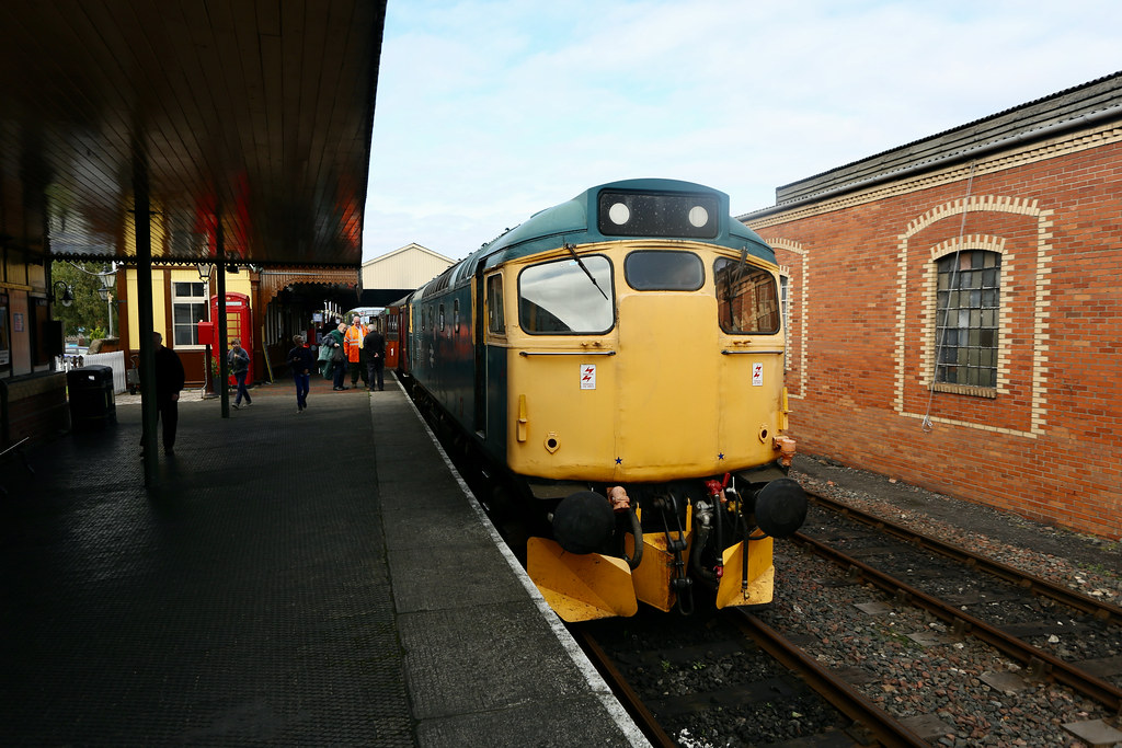

After a warming lunch of soup, coffee and cake at food@34a I headed home, catching sight of the 12:30 departure as it rounded the curves along the foreshore.
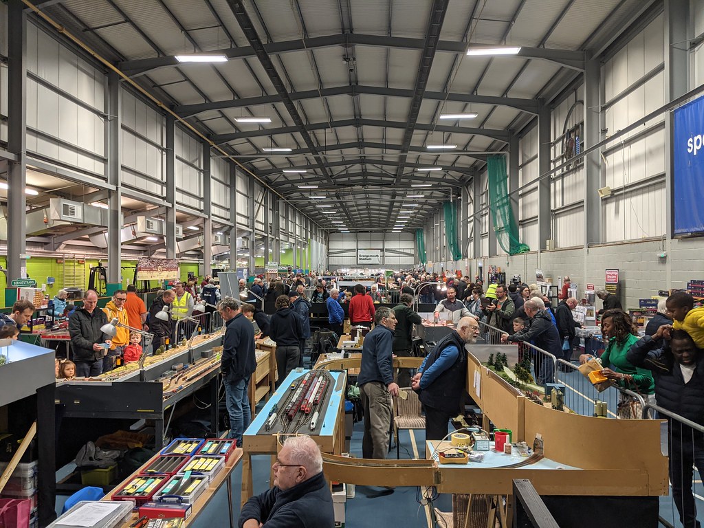
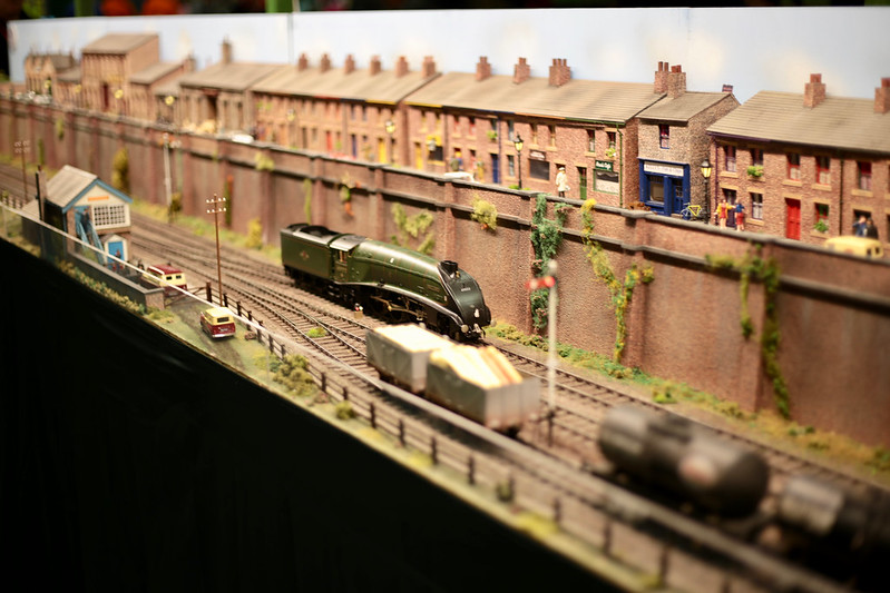
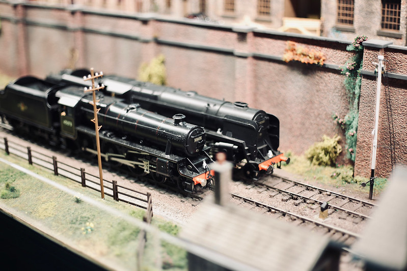
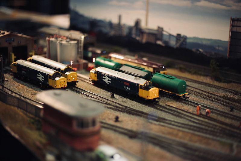
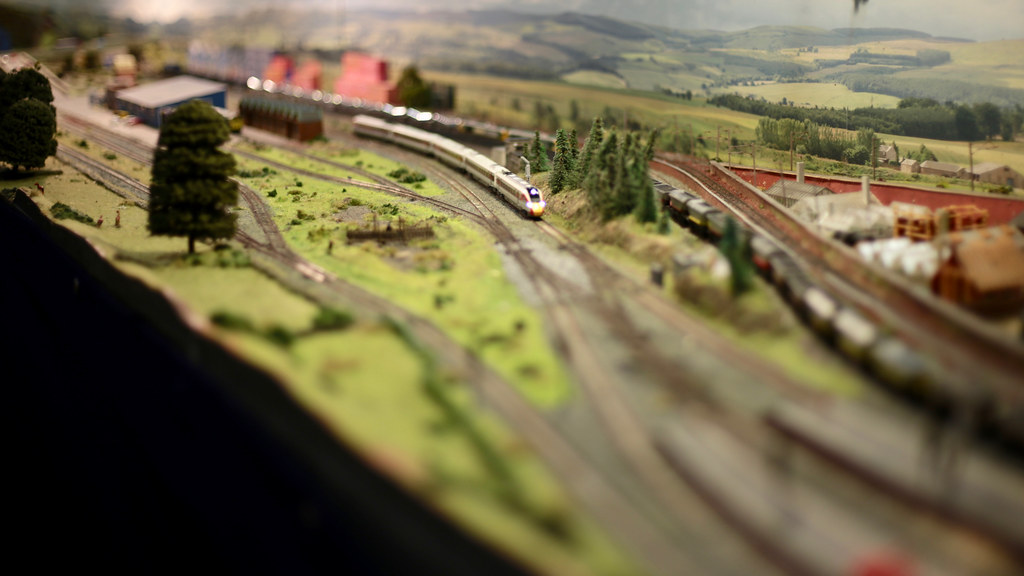
Perth Model Railway Show
Perth Model Railway Show is one of the easier shows for me to access via train and so I found myself on a service from Stirling through to Perth on Saturday morning to attend the show. Held at the Dewars Centre there was already a fair queue by the time I arrived a few minutes before opening time. Once the doors were open everything moved quickly and I was soon inside. The show took up two large halls and there were plenty of layouts to enjoy.

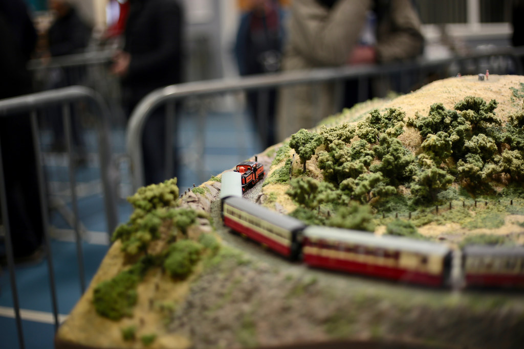
Whithorn by Alisdair MacDonald. An utterly charming 4mm EM gauge layout set in the quiet south-west of Scotland. The sleepy branch line runs between fields, over streams and past railway cottages, all lovingly modelled.

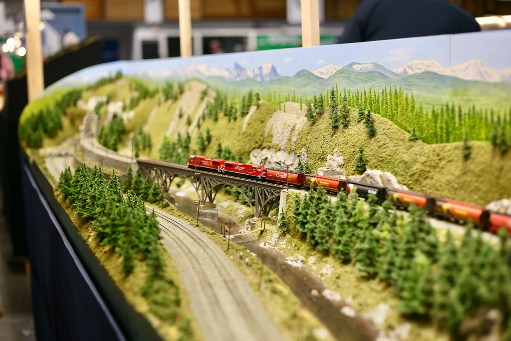
Calla Fountain Crossing by Perth MRG. A North American layout with two separate running lines providing plenty of visual interest as trains crossed rivers and dipped through tunnels. The lengths of some of the freight trains running the sinuous curves of the layout was particularly impressive, even in N scale.
Eli Wood by Eric Farragher. Another impressive layout with two separate running lines offering up a variety of services: short DMUs on the winding branch line at the rear, and full length passenger and freight services on the mainline. The layout featured a rich countryside and captured the feel of quiet country villages.
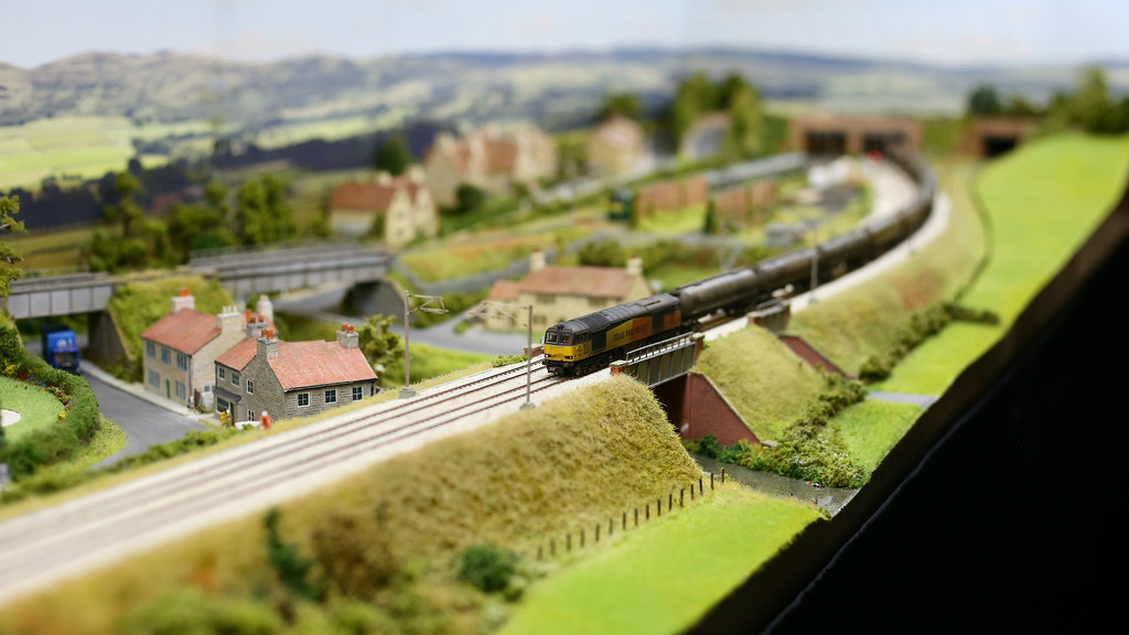
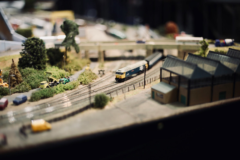
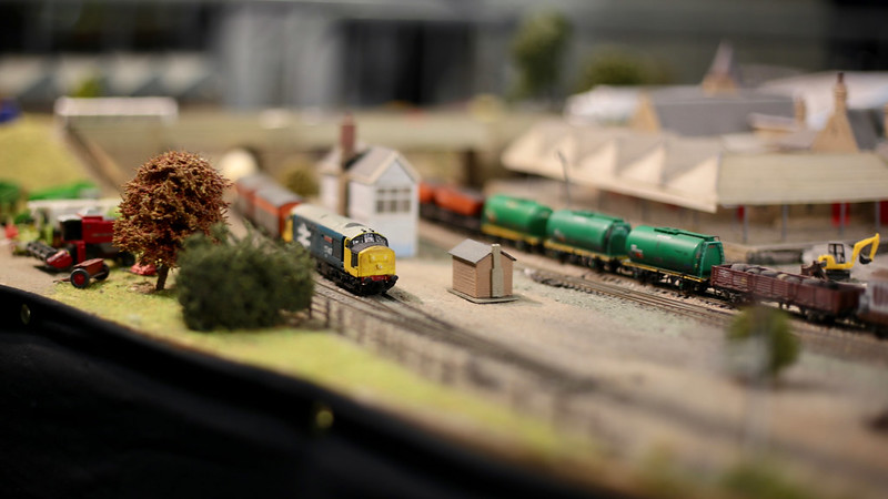
Montague Field by 57 Study Group. Trains took a back seat on this richly detailed industrial dockside layout in 00 gauge. A number of shunters shuffled wagons around but it was the level of detail in the wharfside industry, the cranes and the atmospheric lighting which really impressed.

Kaninchenbau by Iain Morrison. An impressive fully automated alpine layout in HOe gauge with a tight and twisting series of loops making the most of a compact space. Controlled by a computer, the trains kept up a constant timetable of services with pauses at signals and stations carefully choreographed to hold the attention of the viewer.

Northallerton by Cleveland MRC. This slice of the East Coast Mainline was instantly recognisable as the station close to my childhood home. The long run gave the N gauge models plenty of space to stretch their legs, and the freight branch heading for the industry on Teesside provided plenty of visual interest.
Cadhay Sidings by Chris Gough. This Southern Railways layout had plenty of beautiful modelling with a wonderful attention to detail in the buildings and landscape. The operational interest was maintained by the use of a proper timetable, signalling, and communication going on between operators and signallers all doing their best to keep the trains running.

Crianlarich by Renfrewshire MRC. Another great N gauge layout, portraying the spot on the West Highland line. There were plenty of BR blue locomotives hauling passenger and freight trains. The station, goods yard and engine shed, along with the modelling of the town itself brought together a very impressive layout.
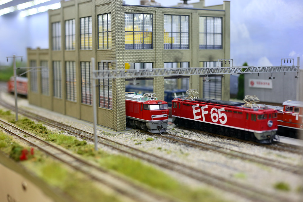
Shuri Koya by Raven Miniatures. There was plenty of attention to detail in this Japanese layout portraying a locomotive deport with suburban services passing by in the foreground.
See my full Perth Model Railway Show album on Flickr for all of my photos. Model Railway in Action on Youtube has lots of great footage of the show and layouts. Part 1 is here.
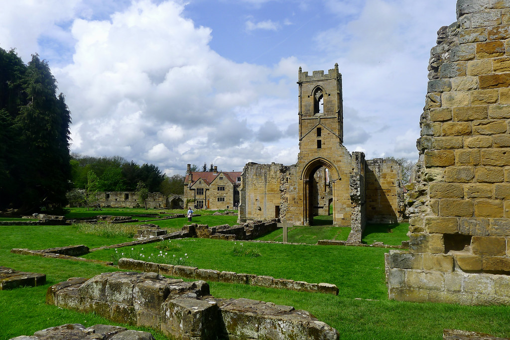
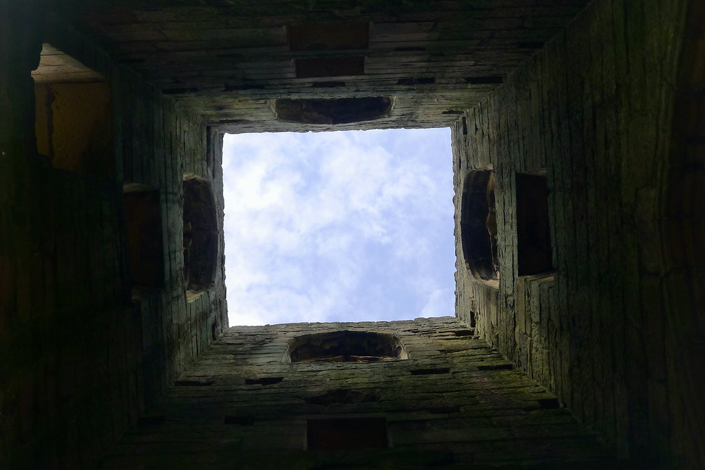
Mount Grace Priory
Whilst on a short trip to North Yorkshire I headed out for a morning to Mount Grace Priory with my parents. Just 20 minutes or so drive from my parents' home, this place was always a popular spot to visit in the summer holidays.
It had been a long time since I'd visited and there has been extensive work undertaken, particularly on redeveloping the gardens in front of the main house. The design work was led by Chris Beardshaw who brought the Arts and Crafts sensibilities of the main house down into the gardens.

The lake and connecting waterways have also been improved and there were a pair of swans reinforcing a substantial nest close to the lakeside. Spring was in full evidence as we also watched a goose family crossing the lake, Mum and Dad flanking a brood of goslings.

We then headed to the remains of the Carthusian monastery, one of just ten established in England.
The reconstructed Monk's Cell is a delight, showcasing simple living centuries before Instagram. Sunlight shone in from the kitchen garden located in the small walled area outside. The garden has been replanted based on recent archeological work that showed it had a mix of medicinal, culinary, flowering and aromatic plants, including some specifically used in church services.

There was blue sky overhead but darker storm clouds forming on the horizon as we walked around the outer walls and the church. Here and there the last daffodils were lingering, whilst in the orchard the trees were heavy with blossom.
Our final stop was the manor house, the former home of the northeast industrialist Sir Isaac Lowthian Bell. The upper floor, set amongst the dark timber rafters has been opened up and they have on display a short film of Lady Bell's Historic Pageant held at the prior in 1927. Rooms on the lower floor have been decorated in the Arts and Crafts style favoured by the Bells.

2022 Music Review
I mostly use Spotify to listen to music and Last.fm to track (almost) all of my listening. Last.fm is connected to Spotify, my phone, AV receiver, and my browser. In recent years it seems to have got worse about duplicate detection so my Last.fm play counts are definitely exaggerated to some degree. I do play music on vinyl and even CD from time-to-time, but don't bother scrobbling these plays.
⭐ Favourite 10 Albums

My favourite albums of the year were:
- Blue Rev by Alvvays
- Dragon New Warm Mountain I Believe in You by Big Thief
- Skinty Fia by Fontaines D.C.
- Classic Objects by Jenny Hval
- PAINLESS by Nilüfer Yanya
- 11:11 by Pinegrove
- I Walked With You A Ways by Plains
- Poster Paints by Poster Paints
- A Light for Attracting Attention by The Smile
- And In The Darkness, Hearts Aglow by Weyes Blood
🎧 Listen to my playlist of favourite tracks from the year on Spotify
🎸 Last.fm Top Charts

My top 10 albums by Last.fm play count were:
- Blue Rev by Alvvays (246 plays)
- Shore by Fleet Foxes (223 plays)
- Dragon New Warm Mountain I Believe in You by Big Thief (209 plays)
- How Long Do You Think It's Gonna Last? by Big Red Machine (198 plays)
- And In The Darkness, Hearts Aglow by Weyes Blood (130 plays)
- I Don’t Live Here Anymore by The War on Drugs (122 plays)
- WE by Arcade Fire (120 plays)
- I Walked with You a Ways by Plains (120 plays)
- Poster Paints by Poster Paints (108 plays)
- Jubilee by Japanese Breakfast (107 plays)
My top 10 artists by Last.fm play count were:
- Fleet Foxes (386 plays)
- Big Thief (286 plays)
- Alvvays (264 plays)
- Dawes (245 plays)
- Big Red Machine (244 plays)
- Taylor Swift (203 plays)
- The War on Drugs (173 plays)
- Arcade Fire (168 plays)
- Midlake (157 plays)
- Soccer Mommy (148 plays)
I scrobbled a total of 14,981 tracks, on average more than 80% of all Last.fm users in 2022.
🎟️ Concerts
The only gig I went to was a special one; Fleet Foxes performing at the Usher Hall in Edinburgh. Their album Shore came out on the day of the autumn equinox in 2020, and was an important moment in a year that lacked much in the way of brightness. It almost immediately became one of my all time favourite albums and hearing the songs brought to life on stage was spellbinding.
Fleet Foxes have subsequently put up an entire recording of their concert on the waterfront in Boston from earlier in the same tour. It's well worth a watch.
📈 Spotify Wrapped


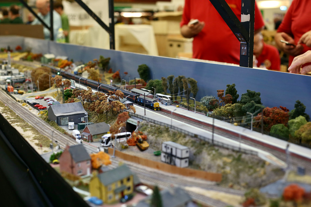
Falkirk Model Railway Exhibition
After a Covid-enforced break, it was great to be back at the Falkirk Model Railway Exhibition which moved to the Grangemouth Athletics Stadium for 2022.
The exhibition was well attended and I enjoyed spending a few hours there on Sunday morning, taking in the layouts and other displays. Here are a few of my highlights.
East Dock by Peter Shields: an O gauge depiction of a small diesel shed in the north east of England in the period 1977-8. The larger scale leant itself well to some highly detailed modelling and there was a good assortment of British Rail blue locomotives trundling around.


Dduallt exhibited by the Greenock and District Model Railway Club. This 009 scale layout depicts the famous spiral above Ddualt station on the narrow-gauge Ffestiniog Railway in the north of Wales. The layout was busy with a constant mix of Double Fairlies pulling passenger trains and engineering trains behind small diesels. The attention to detail is exquisite and the run through the trees at the back of the circuit made for some very attractive scenes beyond the loop itself.

Elgin exhibited by Ted Burt. This N gauge layout is always great to see in person. Its sweeping curves and variety of rolling stock provide constant interest with the goods yard and station providing two different focal points.
Falcon Road by Ian Harper of the Scarborough & District Railway Modellers. A fabulous O gauge layout with lots of big steam engines and Deltics shuffling up and down an impressive run of track with lots of great background detail amongst the shops and houses. The slow, deliberate shunting movements really allowed time to admire the locomotives.

Swinton TMD built by Michael Swinton, a member of the Edinburgh & Lothians Miniature Railway Club. An OO gauge depicting a fictional DRS TMD loosely modelled on Kingmoor TMD, Carlisle. It's always good to see a strong collection of blue 37's idling on the shed, alongside some more modern locos and stock.
Below are few other photo highlights from layouts including Hallmark TMD, Rannoch, Canalside Ironworks, Kinlochewe, Glasshouse Loan and Levenbank.


See the full photo album on Flickr.
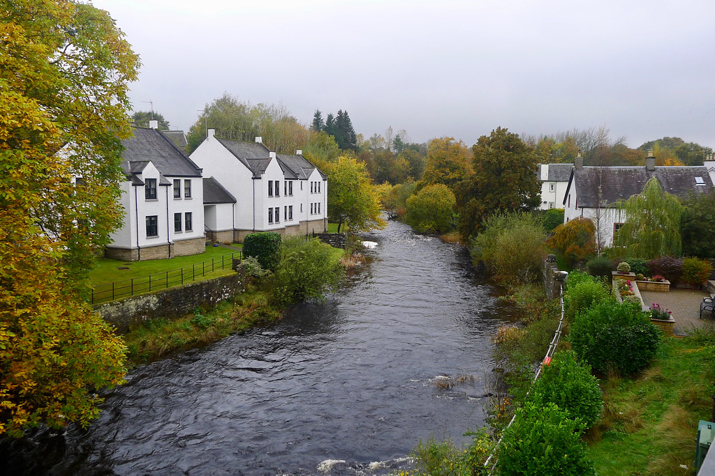
Dunblane Cathedral
Leslie had an event on in Dunblane; after dropping her off I had some free time to explore the town. In particular I wanted to visit the cathedral which is famous for its stained glass windows.
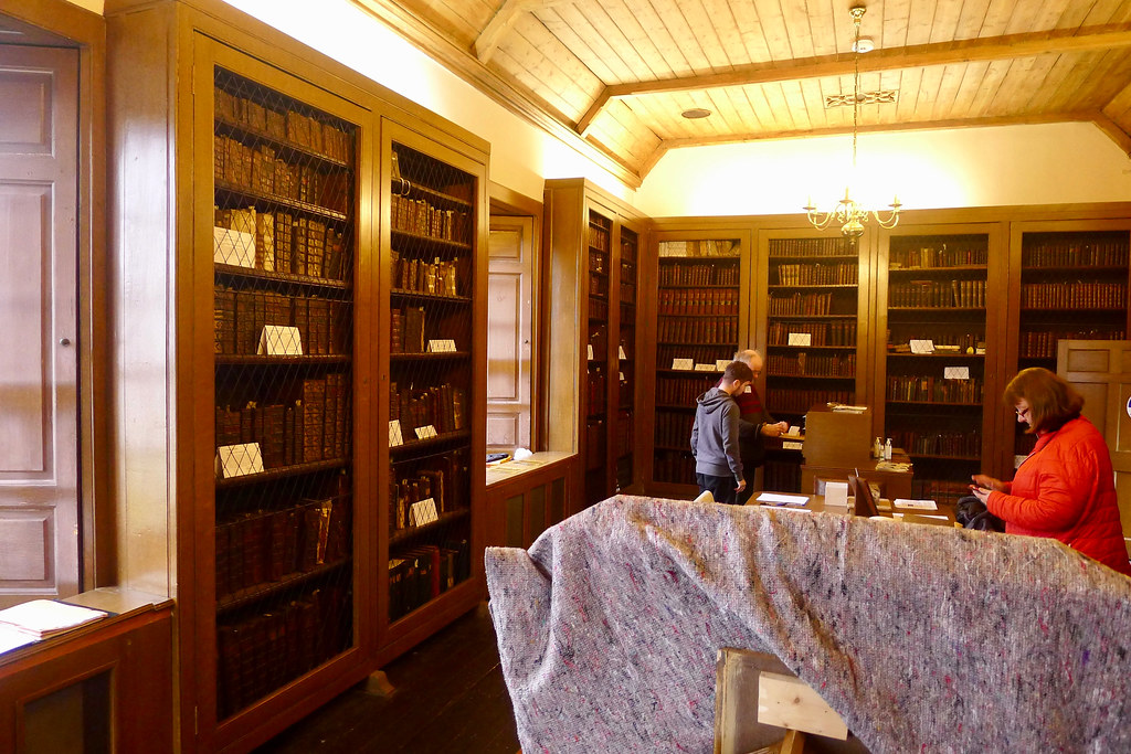
On the walk up from the station I passed the Leighton Library, which happened to having an open day. It is the oldest purpose-built library in Scotland and was built to house the collection of Robert Leighton, Bishop of Dunblane and later Glasgow. The single room has walls lined with wooden bookcases whilst the centre is filled with desks, reading stands and display cases. The collection is eclectic with history, language, exploration and fiction all sitting alongside one another. Outside the casement windows the garden was resplendent in the colours of autumn.
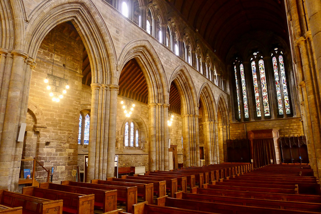
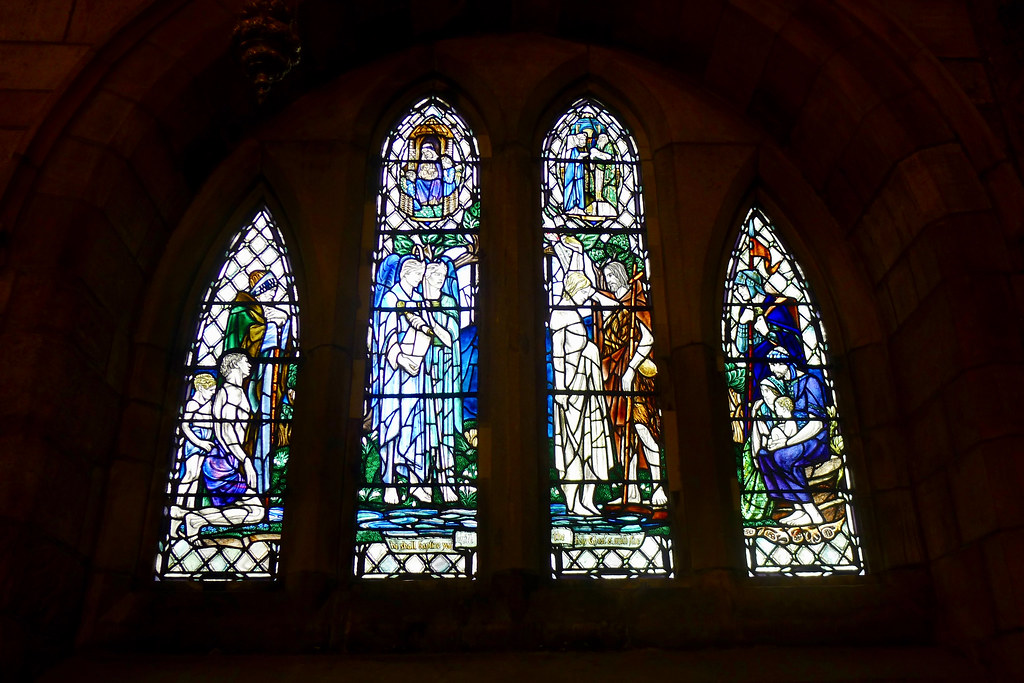
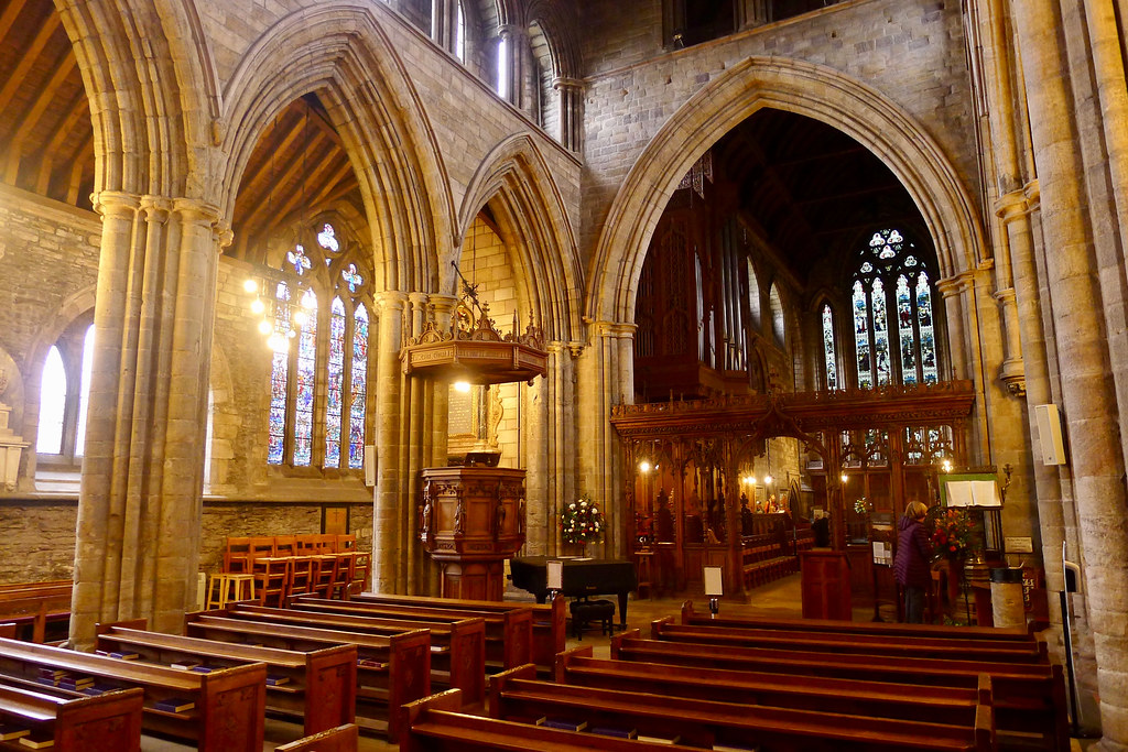
Just a short walk further up the hill brought me to the cathedral. Run by Historic Scotland, entry is via donation. I followed the suggested tour in an anticlockwise direction, starting with the choir and chapter house, and then taking in the aisles on either side of the Nave.

The southern walls of the choir are dominated by a series of large stained glass windows, designed by Louis Davis and installed in 1915. The choir stalls block easy viewing of these windows in places but it was possible to make out the names of those who died in the Antarctic under Scott in 1912. These are placed at the foot of the appropriately named Chaos window depicting storms and the violence of nature.

In the Chapter House, a number of smaller windows are much easier to see and appreciate. The detail and colour in the Transfiguration window, designed by Gordon Webster, were particularly striking.

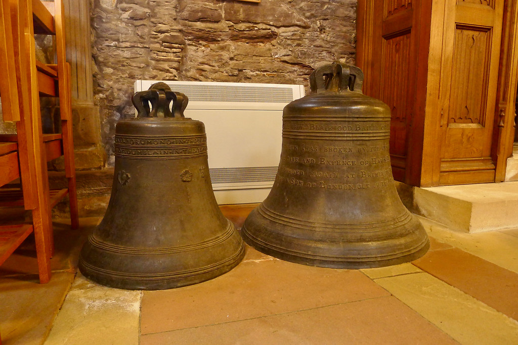
Along the North Aisle is the Tenison window, a multicolour extravaganza depicting the Compassion of Christ_ and designed by Gordon Webster. Further along are two of the cathedral bells, the Great and Lesser bells which were founded in the 1600s.
After visiting the tiny Clement Chapel I continued along the South Aisle where the moving memorial to the victims of the 1996 tragedy in Dunblane sits. Above this are the Barty Windows, another creation of Louis Davis. These windows depict scenes from the Song of Simeon with beautiful figures amongst motifs of clouds, storms and sky.

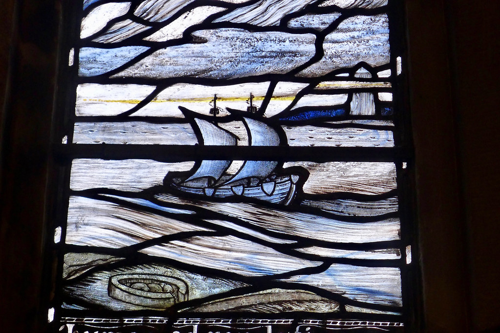


The other large window along the South Aisle is the Baptismal Window, designed by Douglas Strachan.
Comet NEOWISE Part 2
19th July
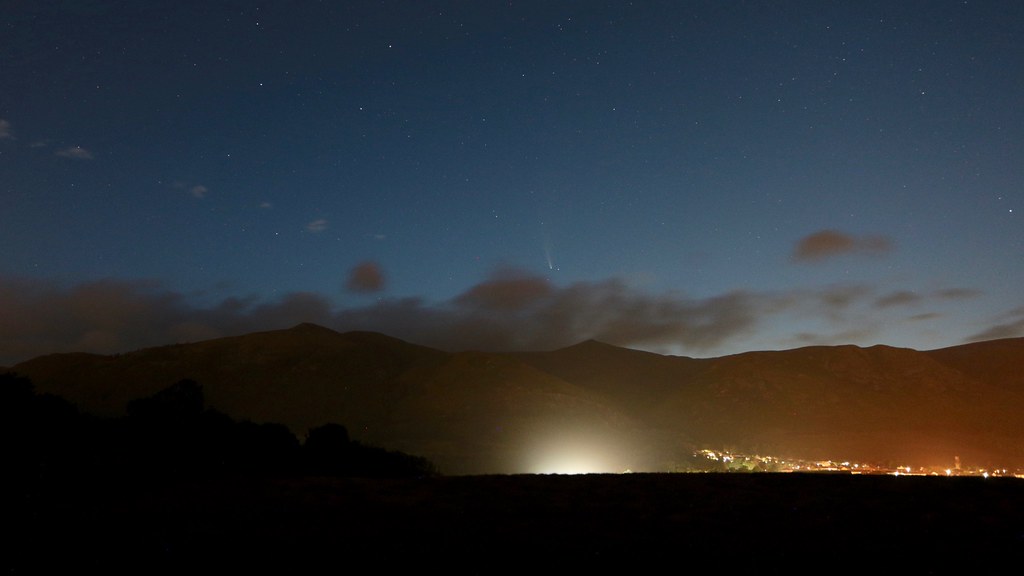
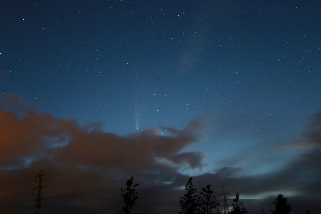
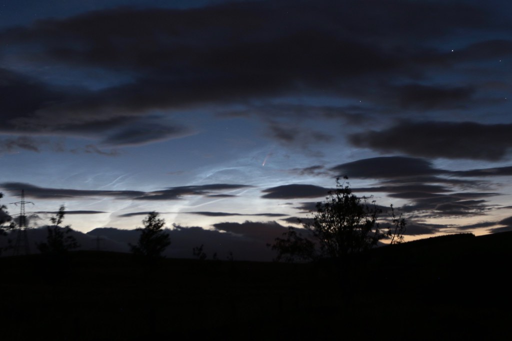
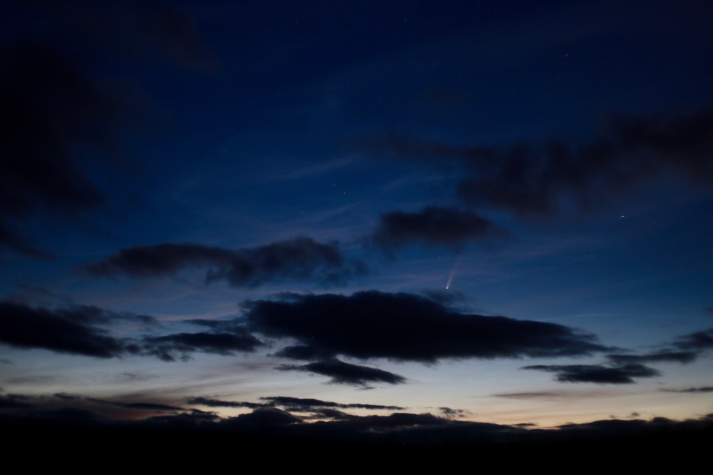
It was the following weekend before I got another chance to observe NEOWISE. This time I drove five minutes from home, parking up on the quiet backroad that runs between Blackfaulds and Coalsnughton. The view from here is of the central Ochil Hills looking out over fields to Alva and Tillicoultry which sadly contribute a bit of light pollution. The skies above the hills were nicely dark, although there was a steady stream of low clouds that occasionally obscured NEOWISE.
 Above: Comet NEOWISE from the Blackfaulds Road at 00:49am on 19th July 2020, 8s exposure at ISO800, 18mm at f/3.5, Canon 450D
The comet definitely was no longer as bright as the previous weekend but still made a very nice sight above the hill. I concentrated on widefield shots and got some pleasing compositions with the hills below. The skies were fairly washed out by approaching dawn but the darkness of the hills below provided some contrast.
 Above: Comet NEOWISE from the Blackfaulds Road at 02:03am on 19th July 2020, 8s exposure at ISO1600, 19mm at f/4, Canon 6D
By the time I was packing up and driving home Venus had appeared, dazzlingly bright over the far eastern Ochils.
 Above: Comet NEOWISE from the Blackfaulds Road at 02:37am on 19th July 2020, 25s exposure at ISO400, 50mm at f/5.6, Canon 450D
July 20th
The next night conditions for comet watching didn’t appear too promising until much later when I stepped outside to see the ISS passing brightly overhead. I noticed the northern sky was almost completely clear and with a little help from the camera managed to spot NEOWISE above the house, positioned between the tops of two tall trees.
Given this might be my last chance to see it this bright I hurriedly set off for the Sherriffmuir Road. Unfortunately the clear window didn’t last very long. NEOWISE looked stunning with a very extensive dust tail clearly visible, but a dark patch of clouds quickly blew in.
 Above: Comet NEOWISE from the Sheriffmuir Road at 00:52am on 20th July 2020, 10s exposure at ISO1600, 40mm at f/4, Canon 6D
I got a couple of widefield shots but by the time the scope was setup for more detailed observation the sky was almost entirely cloudy. In the south I spent a few minutes observing Jupiter and Saturn before they too succumbed to the clouds. It was a shame as this would likely be the last really good night to see the Comet.
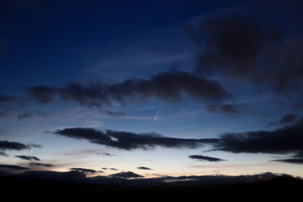
July 24th
After a couple of beers during the evening I suddenly found a clear sky overhead as midnight approached. I packed up my cameras and tripod and cycled across the strath to the road above Marchglen. Here the cyclepath continues on and there is a concrete platform which provides an excellent viewpoint over the Ochils.
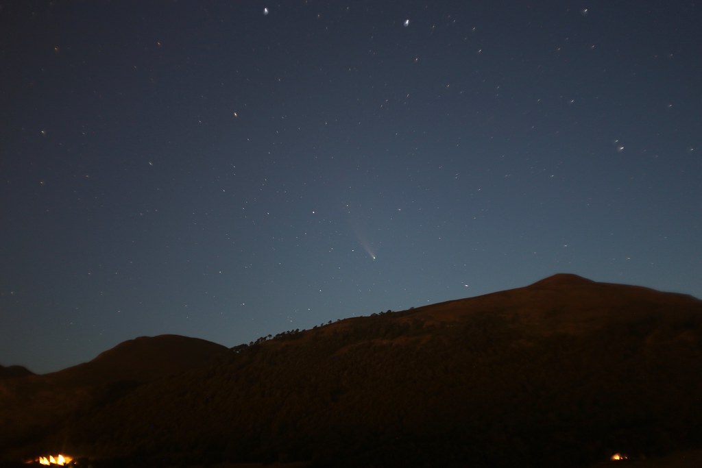 Above: Comet NEOWISE over Wood Hill. 02:04am on 24th July 2020. 8s exposure at ISO1600, f/1.8, 50mm, Canon 6D.
By this time, now just over twenty days since perihelion, the comet was much dimmer and was not immediately obvious to the naked eye, even with reasonable conditions and low light pollution. Nevertheless I was confident it was high enough to be above the hills and so I set up the camera and fired off a test shot. NEOWISE was immediately visible in the photo and so I was able to tweak the framing and then started taking a series of photos.
The fact it was no longer naked eye visible was a little disappointing but I enjoyed viewing it through the camera where it was remarkably bright, even on just a 4s exposure. I suspect the bright northern sky was simply not providing enough contrast for a final naked eye view.
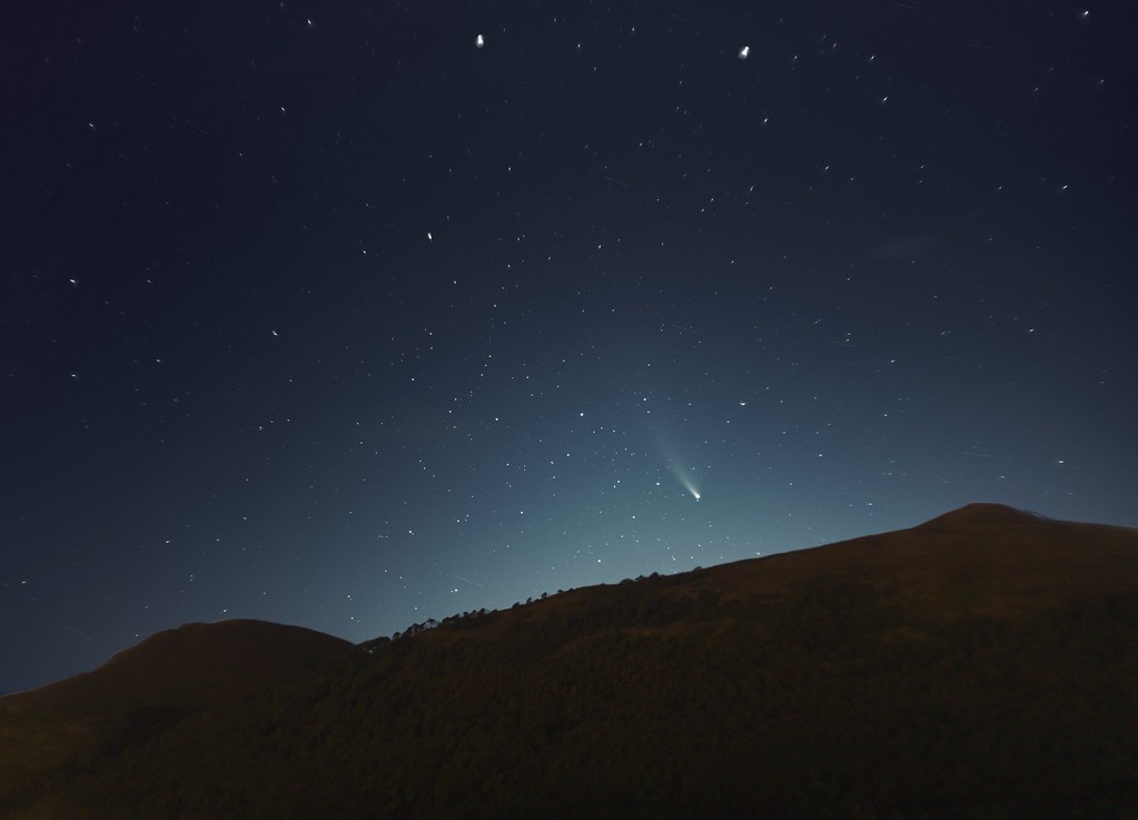 Above: NEOWISE over Wood Hill, Ochil Hills, on 24th July 2020. Two separate photographs, blended. Sky: 27 x 4s exposures at ISO1600, f/1.8, 50mm. Foreground: 1 x 4s exposure at ISO1600, f/1.8, 50mm
I continued taking photos for a good hour or so until the comet slowly dipped below the dark outline of Wood Hill. I was able to use the photos I’d taken to produce both a pleasing timelapse, and a detailed stacked image (above) which revealed the faintest hint of the ion tail and the vast span of the dust tail. Given the challenging conditions I was really pleased with how this one turned out.
Epilogue
After an incredible few weeks, and getting to see NEOWISE on five separate nights, this would be the last I would see of the comet. The next time the skies cleared it had dimmed into near obscurity and was low in the northeast, poorly placed for observation from our garden. Nevertheless it had been the most wonderful thing to have witnessed, the memories of which will hopefully last me until the next bright comet comes along.
Comet NEOWISE Part 1
For several days leading up to the second weekend of July the internet had been buzzing with the first thrilling naked eye observations of Comet C/2020 F3 (NEOWISE). The comet had been first sighted by the WISE space telescope, an earth orbiting satellite that had most recently been looking out for near-Earth objects (NEO), in late March. As the comet rounded the Sun on the 3rd July, the 5km wide icy ball rapidly brightened to around 2nd or 1st magnitude, making it naked eye from even a modest dark sky. People with clear skies were capturing some beautiful images of the comet in the dusky glow of twilight and it was getting better every day. After the disappointing fading of comets SWAN and ATLAS earlier in the year, NEOWISE was shaping up to be a sight to see, likely the best comet since the brief appearance of Comet McNaught in the northern hemisphere in early 2007, and before that, Hale-Bopp in 1997.
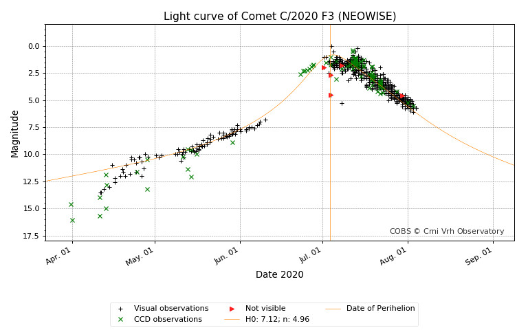 Above: the light curve for Comet C/2020 F3 NEOWISE as determined by recorded observations. Data and graph from the Comet Observation Database.
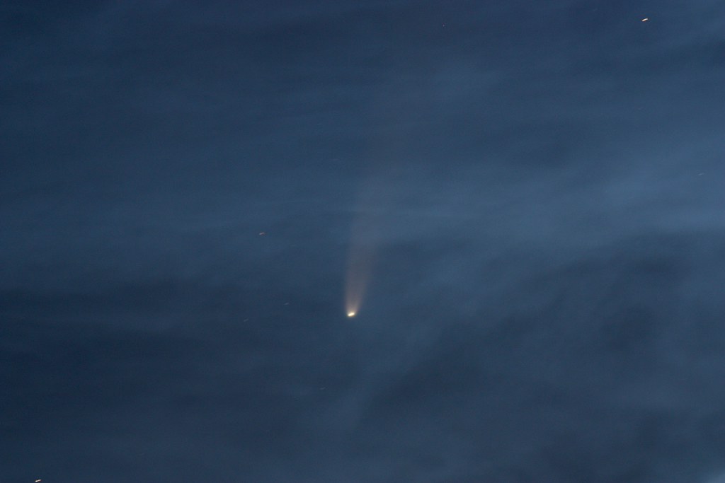
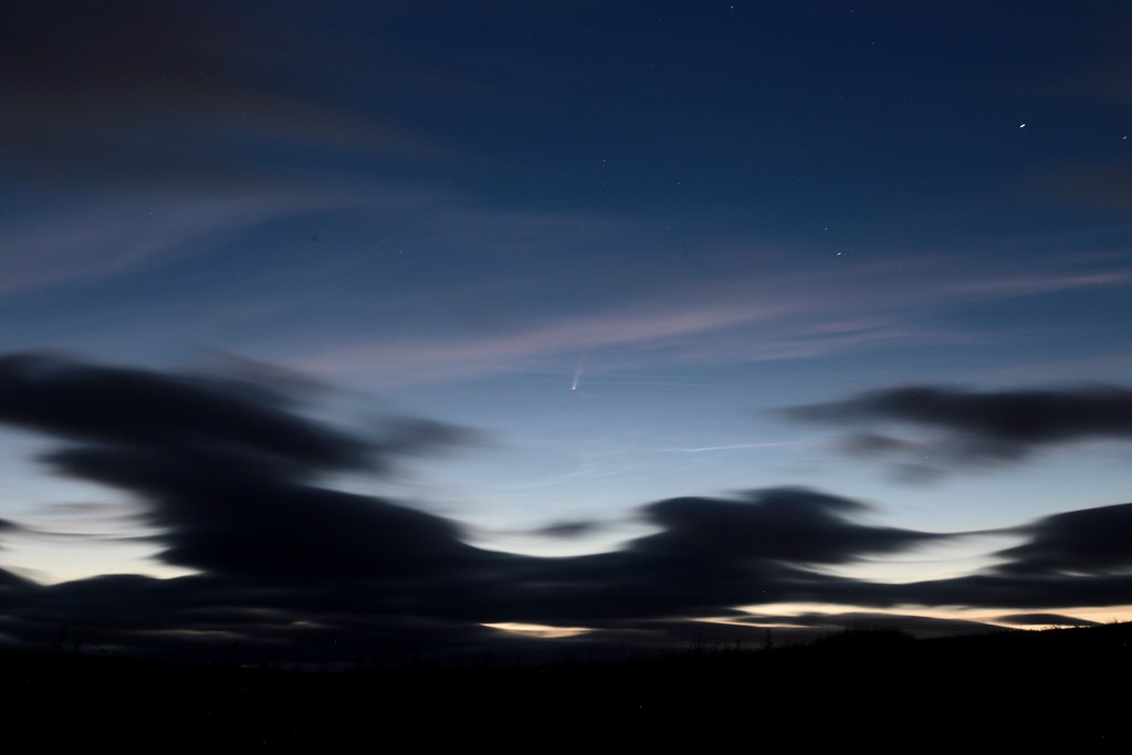
11th July
To see NEOWISE for myself I ideally needed clear northern skies on a weekend night as I knew I wasn’t going to be getting to bed before 3am if all went well. My first chance to view the comet therefore came into the early hours of the 11th July with a forecast set for clear intervals. I set an alarm for 00:45 and Leslie and I bundled up and drove west and up to the top of the Sherrifmuir Road. This climbs onto the western shoulder of the Ochil Hills, north of Stirling and allows for a good northern view with very little light pollution in the direction of the Highlands. It was a cool, pleasant sort of summer's night with just a touch of a breeze.
Of course, at 56N it is still pretty light at this time of year but at the darkest point of the night, with just a bright band of light along the northern horizon, we stepped out to dark, reasonably clear skies and - most importantly - Comet NEOWISE very clearly visible! It was a beautiful sight, the bright nucleus of the comet easily seen with the fainter dust tail trailing out above and to the right. It was an almost unreal sight, this wanderer from the outer solar system standing out clear and bright against a backlit summer sky.
 Above: my first image of NEOWISE taken at 01:46 on 11th July 2020. Canon 6D, 17-40mm lens at 40mm, f/4, 6s, ISO800
We spent a few minutes just gazing at it, before using binoculars and then finally getting the 80mm telescope trained on it. It was an utterly incredible sight. To the eye it appeared white but the telescope revealed a golden aura to the comet. The dust tail was clear, stretching wide across the field of view like a searchlight.
 Above: a view of Comet Neowise through the 30mm eyepiece on a Vixen ED80 telescope taken with my Pixel 2. Neowise is reversed due to the mirror diagonal.
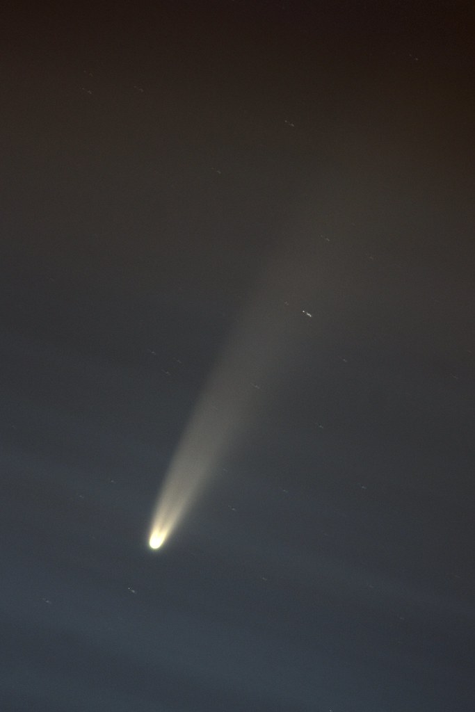
Faint noctilucent clouds had already appeared in the sky by this point, their shimmering silvery tendrils extending out across the northern horizon. This was an exciting development (I hadn’t seen a good display for a few years) but it soon became clear that they were going to cause us to lose naked eye sight of the comet as the contrast of the sky rapidly decreased. Nevertheless the views of NEOWISE through the telescope remained and I eventually hooked up the camera to get a few detailed photos. The noctilucent clouds did wash out a lot of the details but made for very beautiful images, the comet seen through a rippling pattern of blues and greys.
 Above: Comet Neowise taken with a Canon 450D at prime focus on a Vixen ED80sf telescope. A single untracked 5s exposure at ISO200.
The NLCs themselves turned into a spectacular display which extended across the whole northern horizon and overhead with complex and intricate structures. They kept me out photographing much longer than I intended!
 Above: Noctilucent Clouds extending across the northern horizon at 03:17am. Canon 6D, 17-40mm lens at 17mm, f/6.7, 4s, ISO400.
To cap off the night I saw two orbits of the International Space Station, managing to capture one as it glided over the nearby hill of Dumyat. I didn't have much time to adjust my settings so was pleased to pick it up in a photo. In the south both Jupiter and Saturn shone brightly but drew little interest with NEOWISE in the sky.
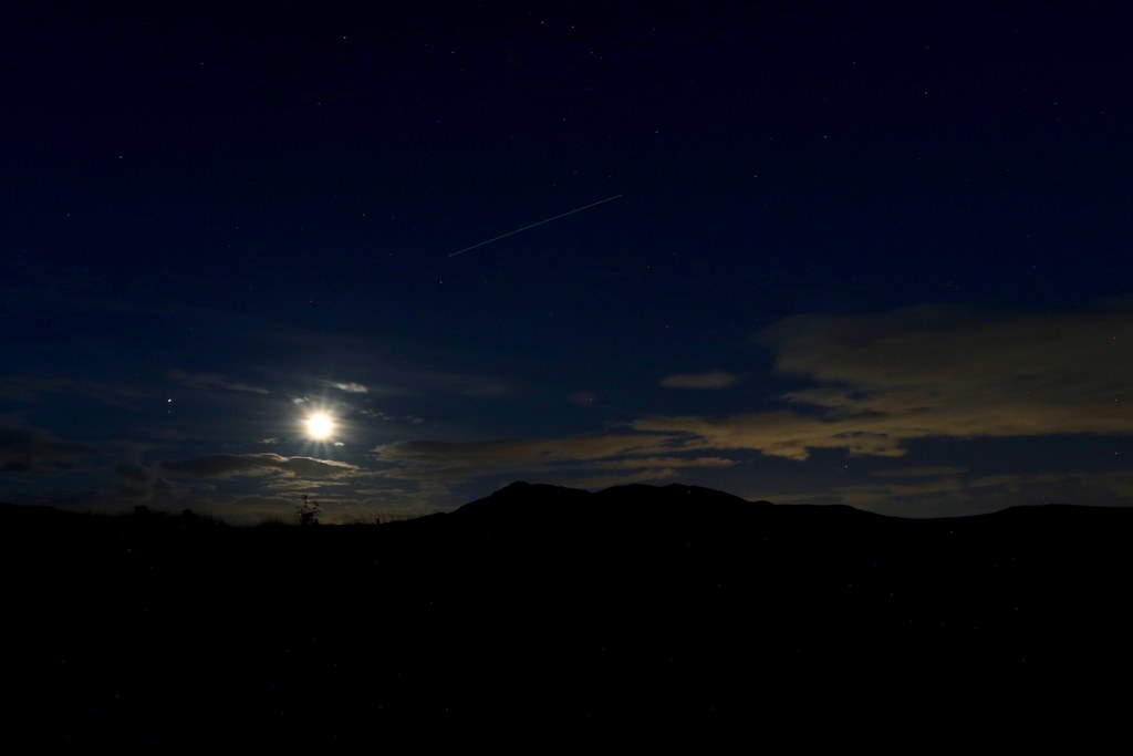 Above: the International Space Station passes over Dumyat at 01:54 on 11th July. Canon 6D, 17-40mm lens at 17mm, f/16, 30s, ISO800.
12th July
After success the previous night I was keen to get out again with another clear spell forecast overnight. This time I drove up to the hills south of Tillicoultry with the hope that I would be high enough to see NEOWISE over the Ochil Hills. Although the hillfoot villages throw up light pollution I was hoping the darkness of the Ochils themselves would provide at least decent viewing conditions.
Sadly, I pulled up to the parking area near Forestmill on the A977 to be greeted by thick clouds and a blustery wind. I sat in the car for an hour, getting out every 10 minutes to stamp my feet and see if a gap had appeared in the clouds. Although the odd slim gap did appear over the dark silhouette of the hills there was no sign of NEOWISE. Back in the car I had a quick look at the satellite images on my phone and decided to try my luck a little further west where it appeared that the cloud might be a little patchier. I drove around to Stirling and then along the road towards Doune where I parked up at the David Stirling memorial which has a commanding view over the Trossachs and, most importantly, a clear northern horizon.
I was greatly relieved on arrival at the dark parking area to see the clouds starting to break up and soon I had my first sight of NEOWISE. In contrast to the previous night the tail was more elongated and seemed narrower and brighter. Despite starting before midnight the cloudy conditions meant I took my first shot only a little earlier than the previous night. With promising skies I set up both the camera and the telescope including getting a rough polar alignment to allow for tracking.
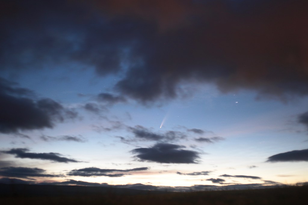 Above: Comet NEOWISE at 01:37BST, Canon 6D, 50mm lens, f/1.8. 3s, ISO1600
Clouds came and went but there were only faint noctilucent clouds so the views were generally better than the previous night. There appeared less colour in NEOWISE's tail but it definitely stretched out to a great extent. Sadly I’d missed the darkest part of the night whilst clouded out so the sky was brightening rapidly and NEOWISE getting fainter.
 Above: Comet Neowise at 01:59BST. Canon 6D, 50mm lens, f/1.8, 1.5s, ISO400
Again I captured a mixture of widefield and telescope photos of the comet before the approaching dawn washed out NEOWISE from the sky. During the night at times when the comet was hidden by cloud patches I also observed Jupiter, Saturn, Mars and the rising moon. It was a beautiful night with the air very still making visual observations of the planets a joy.
 Above: Comet Neowise at 02:04BST. Canon 6D, 50mm lens, f/1.8, 1.5s, ISO400
 Above: Comet Neowise at 02:39BST. Canon 6D, 50mm lens, f/11, 30s, ISO400
I was able to stack a number of my telescope images to create a nice portrait of NEOWISE against the subtly-clouded sky. My tracking wasn't perfect but the alignment done by the software resulted in a decent image with some detail seen in the dust tail. There was no hint of any ion tail despite my best efforts to stretch the image.
Above: Comet Neowise. Vixen ED80sf Telescope, Canon 450D, 10 x 5s exposures, aligned and stacked in Nebulosity and processed in Darktable
With dawn approaching I packed up and drove home, very happy to have got clear conditions after the somewhat disappointing start to the night.